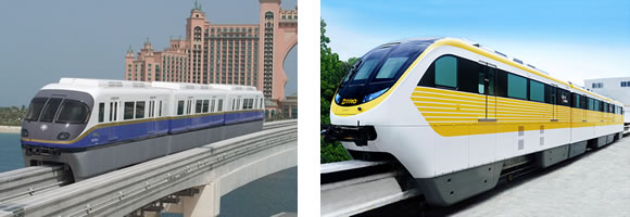
Examples of two Hitachi monorail trains elsewhere in the world.
(Showing two different train models)
Still the Best High-Speed Mass Transit from West Seattle and Ballard
by Bob Fleming
Why would monorail be better than light rail for this route?
A Brief History
In November 2005, Seattle residents voted to kill the Seattle Monorail Project that was to build the Green Line, the first of several lines that would eventually form a network of rapid transit monorail lines in Seattle. Poor planning and possibly bad management resulted in underfunding that resulted in several problems, which were taken advantage of by opponents to kill the project.
Now concern about global warming and increasing traffic congestion are rapidly creating new demands for mass transit. I think that the public needs to be convinced that the Green Line was basically a good idea and that we should try again, but with changes that will satisfy more people and avoid errors of the past. But now the idea of a monorail reminds most people here of the expensive failure of the Green Line project that has left a bad taste in people’s mouths. What went wrong?
Here are my ideas for building a new version of the Green Line that would avoid past problems and would better provide better service than the previous plan:
The Route:
THE ORIGINAL ROUTE — The plans for the original Green Line, from north to south, was for it to begin at N.W. 85th St. and 15th Ave. N.W. in Crown Hill, then go south along 15th Ave. N.W., 15th Ave. W. and Elliott Ave. W. through Ballard and the Interbay area, then east on W. Harrison St. to pass through the grounds of Seattle Center to 5th Ave. N., then south on 5th Ave. N. and 5th Ave. to Virginia St., then west to 2nd Ave, then south along 2nd Ave. through Downtown Seattle. It would then continue south through the SODO area to S. Spokane St., where it would use the West Seattle Freeway to reach the Alaska Junction area in West Seattle, then south along along California Ave. S.W. to S.W. Morgan St. See map of original Green Line.
ROUTE: DOWNTOWN SEATTLE — I think the best route through Downtown Seattle is along Second Avenue, all the way from Second Avenue and Denny Way to Second Avenue and Yesler Way, basically like the original Green Line plan, except that the original plan called for a route along Fifth Avenue north of Virginia Street, and then shifting west to Second Avenue at Virginia Street. I think it would be better to take Second all the way. I explain my reasoning below in discussing the route to Ballard and Crown Hill.
ROUTE: DOWNTOWN TO BALLARD AND CROWN HILL — From Second Avenue and Denny Way, the monorail line would go northerly to a station near the southwest corner of Key Arena. This Key Arena Station could also be the terminus of an extended Seattle Center Monorail line to permit transfers between the two lines.
Unlike the original Green Line plan, my route would not take a loop through the Seattle Center and along Fifth Ave. N. and Fifth Ave. to Virginia St. before moving west to Second Ave., but rather take a much more direct route along Second Ave. This would not only save a lot of money in construction costs, but would also save time in travelling the route and avoid the controversy over the monorail running through the Seattle Center grounds.
From the Key Arena Station, the line would run along Harrison St. and W. Harrison St. to Elliott Ave. W., then northwesterly along Elliott Ave. W. to W. Garfield St., where Elliott Ave. W. curves into 15th Ave. W. A Garfield Street Station could be built near here, which would serve local industry, the nearby cruise terminal, and permit bus transfers to Magnolia Hill. There is also the possibility for a branch monorail line directly serving the cruise terminal.
From the Garfield Street Station, the line would proceed north along 15th Ave. W. until somewhere south of W. Dravus St., where it would deviate about a block west to a Dravus Street Station just west of 15th Ave. W. at W. Dravus St. From there the line would go north to a high-level bridge crossing Salmon Bay into Ballard, someplace south of N.W. Market St., where there would be a Market Street Station serving the nearby Ballard business district.
The high-level bridge would be high enough to clear marine traffic, and there is the possibility that the bridge could be designed to also handle vehicular traffic so traffic does not have to use the Ballard Bridge, a drawspan subject to opening for marine traffic. The bridge would then be a joint project of the monorail agency and Seattle Department of Transportation, saving money for both agencies than if two separate bridges were built.
As in the original Green Line plan, the route would continue north along 15th Ave. N.W. to a station at N.W. 65th St. (Ballard High School) and a Crown Hill Station at N.W. 85th St., the northern terminus of the line. There is the possibility of extending the line in the future northeast along Holman Road N.W. then east to Northgate and Lake City.
ROUTE: DOWNTOWN TO WEST SEATTLE — From 2nd Ave. and Yesler Way, the line would proceed south roughly along Occidental Ave. S. (one block east of 1st Ave. S.), passing CenturyLink Field (Seattle Seahawks football and Seattle Sounders soccer) and Safeco Field (Seattle Mariners baseball) and then the proposed new arena for NBA basketball and NHL hockey. If the monorail is built past these sports venues, and if large parking facilities are built elsewhere along the monorail line, much of the parking around the sports facilities could be eliminated and therefore much of the traffic, reducing conflicts with industrial and port activities.
From the sports facilites in Sodo, the line would continue south and then west on the West Seattle Freeway to West Seattle, and then more or less follow the original Green Line route. There is the possibility of future extension of the line to White Center and Burien.
Trains:
TRAINS — There are now several manufacturers of monorail trains. Currently my personal preference is Hitachi trains. They have been building monorails since the 1960s and have a large number of systems installed in various parts of the world. They have three basic sizes of trains, small, medium, and large. The large trains are similar in size to light rail cars and the Seattle Center Train built by Alweg. In fact the Hitachi trains are based on the Alweg design. Click here for more about Hitachi monorails. For a complete list of monorail manufacturers, go to this page on the monorails.org website.
Funding:
FUNDING — The earlier project was funded solely from MVET (motor vehicle excise taxes) and the original projection of revenue was too low. This led to cutting back on some project details and still the resulting financing package was for at least 50 years at fairly high interest rates. The new financing package must be guaranteed to pay for the project and that the debt can be paid off in a reasonable time with low interest rates.
FUNDING SOURCES — The previous project put the entire tax burden on Seattle vehicle owners. The new tax package should avoid putting too much of a burden on any particular group of people, but rather spread the tax load across most of the people of Seattle and many people coming into Seattle, because mass transit will improve the city and the region, and everybody should help pay for it. Residents of King County outside of Seattle will also derive some benefits for traffic improvements in Seattle, so it is reasonable to also tax those people, but at a much lower rate than Seattle residents.
Possible taxes could include:
None of these taxes should be very high, for instance maybe a 0.1% MVET in King County with an additional 0.2% in Seattle, and an 0.1% sales tax (1 cent for every ten dollars spent) in King County and an additional 0.1% in Seattle.
Ownership:
OWNERSHIP — The original project was a grassroots effort by the people of Seattle, and was under the jurisdiction of the City of Seattle. I suggest that the new effort be controlled by King County Metro Transit. This will place the planning, construction, ownership and operation in the hands of an established mass transit agency. The Green Line would only be inside the Seattle city limits, but would be used often by many King County residents living outside of Seattle. Now that Sound Transit, the proposed ST3 expansion project, is considering light rail in the West Seattle - Downtown - Ballard corridor, I suggest that Sound Transit should seriously consider using monorail for this corridor and then Sound Transit would be the owner of the monorail. However since the monorail would be entirely withing the Seattle city limits, I think it fair that an additional portion of the tax burden fall upon the residents and businesses of Seattle, and upon visitors to Seattle.
Track and Stations:
DUAL GUIDEWAY — In order to cut costs, the previous project planned a single guideway (track) on some segments of the monorail line. The new plan should have dual guideway (double track) for the entire length of the line. This gives flexibility to run trains closer together as needed. The Green Line is intended to be a rapid transit system and any unnecessary delay in travel time should be avoided.
PLAN FOR LONGER TRAINS IN THE FUTURE — In order to save costs, the first trains could be two car trains (consists), but longer trains could be obtained later if needed. In order to save construction costs, build stations for two-car consists, but design them in such a way so that they can be easily extended later if longer trains are added to the fleet.
PLAN FOR FUTURE STATION IMPROVEMENTS — In order to cut initial costs, stations can be designed in a more basic style, but in such a way that they can be beautified later without much problem.
PROVIDE ADEQUATE PARKING — The earlier plan for the Green Line provided for very little parking at the monorail stations. It was intended that people would take a bus to the monorail stations. However such planning is unrealistic. It would be nice if as few people as possible drove, however in real life there are many people who are too far from a bus stop or for other reasons can’t reasonably take a bus. It is better to have people drive only from home to a monorail station than to drive all the way to their destination. Adequate parking should be provided at stations outside the Downtown area to encourage those that must drive to use the monorail for part of their trip.
Construction Schedule:
CONSIDER BUILDING IN STAGES — The total cost (excluding financing) of the Green Line from West Seattle to Crown Hill will probably exceed $2 billion. Public opinion is more likely to oppose an expensive project than a less expensive one. I would like to see the entire project done at once, but it may be better initially to push for a shorter section and then extend it later. Once the initial segment is operating and people can experience it, public opinion should be stronger in favor of building the rest of the line.
I would suggest a starter line from Sodo to West Dravus Street, with a major parking facility at the Dravus Station. This line would serve the sports venues in Sodo, Downtown Seattle, the Seattle Center and Key Arena, and the parking facilities at West Dravus Street would provide not only parking for those wanting drive that far yet avoid parking downtown, but also provide parking for attendies at sports venues at Seattle Center and Sodo, and help relieve congestion in Sodo. A large parking facility in Sodo would also be great, but there would have to be good access to/from I-5, I-90, and the West Seattle Freeway in order to avoid creating congestion on Sodo surface streets.
Return to the monorail home page Contact Us
©2008 Robert M. Fleming Jr.
This page was last updated on 13 October 2018.